Map
Map
St. Laurent du Var
Today's Surf Conditions at St. Laurent du Var
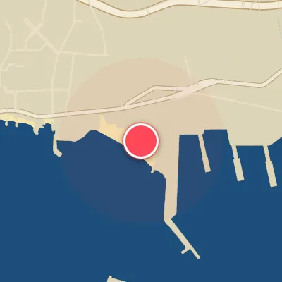
Spot Conditions Map
Hover over the hourly chart columns to update the wind & swell direction overlays on the map.
Today's Surf & Wind Forecast (Hourly)
Loading forecast text...
Spot Overview & Description
St-Laurent du Var is a sand-bottom rivermouth left that sits right next to the tarmac of Nice Airport, where the Mediterranean meets the runway. On those rare, glassy days when the swell lines up just right, this cold, murky setup can spit out long, hollow barrels that are as raw as they are elusive. The lefts look tempting from the beach, but don’t be fooled—powerful rips and questionable water quality make this a wave best suited for intermediate to advanced surfers who know how to read a shifting sandbar and handle a current. Beyond the rivermouth, onshore beachbreaks stretch past the nautical centre, the Hippodrome, and the harbour. When the biggest swells roll in, a distinct A-frame rears up among the peaks, offering a tough but rewarding challenge for those willing to brave the chop and the crowds.
Best Surf Season & Climatology
Best Surf Season (October - March)
The Mediterranean winter, driven by stronger low-pressure systems tracking across the Gulf of Lion and the Ligurian Sea, delivers the most consistent and rideable conditions to St. Laurent du Var. From October through March, average swell heights hover around 0.5-0.6m with periods of 5.1-5.7s. The key is that the dominant swell directions shift favorably: while the S, SSW, SW, WSW, and W windows account for a significant share of the wave energy – nearly 50% of all swell in January, for instance – the wind regime also tilts in our favor. Offshore winds from the N, NNE, NE, ENE, and E quadrants blow most frequently, with ‘ideal for surfing’ percentages peaking at 35-36% in November and January. This is when the North Polar Jet and the Atlantic storm track align to send long-period pulses into the basin. Although the average period stays in the ‘average, punchy’ range (5-6s), occasional 10-14s groundswells can transform the beach into a powerful, rippable playground, especially when a strong Mistral or Tramontane clears the sky and polishes the lines. The window from late November to early February offers the highest probability of scoring fun, shoulder-high sets with clean, offshore texture.
Fair Surf Season (April - May & September)
During the shoulder months of April, May, and September, the Mediterranean transitions and surf quality becomes more inconsistent. April sees an average swell height of 0.5m and period 5.1s, with only 25% ideal wind. The S to SW swell window still contributes around 30-35% of total energy, but a growing share comes from the E and ESE – not optimal for St. Laurent’s SW-facing beach. These easterly swells are typically short-period (4-5s) and small, often mushy and choppy. By May, average swell height drops to 0.4m and period to 4.7s, with ideal wind plummeting to 15%. The swell direction charts show a dominant SSW and SW contribution (over 44% combined), but the heights are in the 0-0.5m range – too small for real surfing. September offers a slight uptick: average swell 0.4m, period 4.5s, ideal wind 16%. The easterly component is still strong (E and ESE account for 25% of swell), but the first autumn lows start to re-introduce more WSW and W swell. On the best days, when a low passes to the north and the wind turns offshore, you can find clean, waist-high waves – but don’t expect consistent overhead sets.
Low Surf Season (June - August)
The summer months from June through August represent the absolute low point for surf at St. Laurent du Var. The Mediterranean is dominated by high-pressure and weak, localized thermal winds. Average swell heights bottom out at 0.3m in July and August with pathetic periods of 4.2s and 4.1s respectively. Ideal wind conditions occur only 7-10% of the time – and even then, the swell is almost non-existent. The swell rose shows that over 80% of all waves are below 0.5m, coming mostly from the S, SSW, and SW directions, but these are essentially windswell generated by the afternoon sea-breeze that also blows directly onshore. The frequent S and SW winds not only ruin wave shape but also suppress any potential groundswell. Long-period energy is virtually absent. The few small waves that do appear are best suited for a foamie or a longboard on a dead-calm morning with an early offshore breeze, but truly, this is a time to explore other activities or appreciate the beach for its sun and sand. Surfable days are rare and limited to micro, groveling conditions.
Detailed Surf Information for St. Laurent du Var
Detailed Surf Forecast
Access our detailed 8-day swell and wind forecast charts for St. Laurent du Var with tidal graphs, period ranges, and daily forecast text summaries.
Swell & Wind Statistics
Explore historical swell consistency, wave heights, and offshore wind windows month-by-month, compiled from over 40 years of data.
Historical Surf Report
Browse the historical database archives to view past wave reports and understand spot climatology during specific years and months.